
Thank you for supporting this site ❤️
Make a donation
Make a donation
Gear up for your next adventure:
As an Amazon Associate, this site earns from qualifying purchases at no extra cost to you.
Kemalelara topographic map
Click on the map to display elevation.
Thank you for supporting this site ❤️
Make a donation
Make a donation
Gear up for your next adventure:
As an Amazon Associate, this site earns from qualifying purchases at no extra cost to you.
About this map
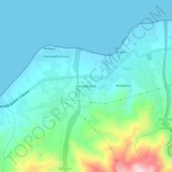
Name: Kemalelara topographic map, elevation, terrain.
Location: Kemalelara, Dato, Liquiçá, East Timor (-8.61861 125.29944 -8.57861 125.33944)
Average elevation: 305 ft
Minimum elevation: 0 ft
Maximum elevation: 1,631 ft
Thank you for supporting this site ❤️
Make a donation
Make a donation
Gear up for your next adventure:
As an Amazon Associate, this site earns from qualifying purchases at no extra cost to you.