
Hochgurgl topographic map
Interactive map
Click on the map to display elevation.
About this map
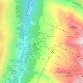
Name: Hochgurgl topographic map, elevation, terrain.
Location: Hochgurgl, Sölden, Bezirk Imst, 6456, Österreich (46.87993 11.03143 46.91993 11.07143)
Average elevation: 7,470 ft
Minimum elevation: 5,410 ft
Maximum elevation: 10,026 ft
Other topographic maps
Click on a map to view its topography, its elevation and its terrain.
Hochsölden
Österreich > Bezirk Imst > Sölden
Hochsölden, Sölden, Bezirk Imst, 6450, Österreich
Average elevation: 6,785 ft
Steinmandl
Österreich > Bezirk Imst > Sölden
Steinmandl, Sölden, Bezirk Imst, 6458, Österreich
Average elevation: 9,081 ft
Zuckerhütl
Österreich > Bezirk Imst > Sölden
Zuckerhütl, Sölden, Bezirk Imst, Österreich
Average elevation: 10,190 ft