Geolocate

Kottarakkara topographic map

Click on the map to display elevation.

About this map

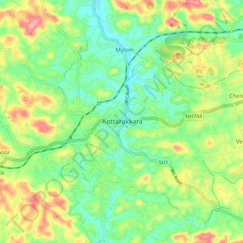
Name: Kottarakkara topographic map, elevation, terrain.

Location: Kottarakkara, Kollam, Kerala, 691500, India (8.96549 76.74320 9.04549 76.82320)

Average elevation: 177 ft

Minimum elevation: 36 ft

Maximum elevation: 407 ft

Other topographic maps

Click on a map to view its topography, its elevation and its terrain.

Kizhakkumbhagom kulam

India > Kerala > Kottarakkara > Chithara

Average elevation: 535 ft

Gear up for your next adventure:

🧤Hiking Gloves - Protective gloves for rugged trails
🔪Outdoor Multitools - Essential survival tools for gear repair and field use
🚗GPS Dash Cams - Record your scenic drives through mountain passes and canyons
🩹Survival Bandages - High‑quality bandages for emergencies
🧭Compass with Lanyard - Easy‑carry compass for navigation

As an Amazon Associate, this site earns from qualifying purchases at no extra cost to you.