Geolocate

Manhattan topographic map

Click on the map to display elevation.

About this map

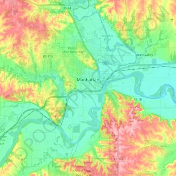
Name: Manhattan topographic map, elevation, terrain.

Location: Manhattan, Riley County, Kansas, United States (39.12413 -96.69028 39.22880 -96.49671)

Average elevation: 1,129 ft

Minimum elevation: 974 ft

Maximum elevation: 1,404 ft

Riley County trails, hiking, mountain biking, running and outdoor activities

Other topographic maps

Click on a map to view its topography, its elevation and its terrain.

Rocky Ford

United States > Kansas > Riley County

Average elevation: 1,086 ft

Gear up for your next adventure:

🧯Emergency Survival Kit - All‑in‑one survival essentials for the backcountry
🧤Hiking Gloves - Protective gloves for rugged trails
Backpacking Tents - Weight-optimized shelters for multi-day topographic surveys
Camping Coffee Makers - Enjoy premium coffee at the summit or campsite
🎁Geography Themed Gifts - Unique gift ideas for map lovers and geography enthusiasts

As an Amazon Associate, this site earns from qualifying purchases at no extra cost to you.