
Thank you for supporting this site ❤️
Make a donation
Make a donation
Gear up for your next adventure:
As an Amazon Associate, this site earns from qualifying purchases at no extra cost to you.
Hornocal topographic map
Click on the map to display elevation.
Thank you for supporting this site ❤️
Make a donation
Make a donation
Gear up for your next adventure:
As an Amazon Associate, this site earns from qualifying purchases at no extra cost to you.
About this map
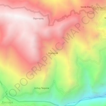
Name: Hornocal topographic map, elevation, terrain.
Location: Hornocal, Canaria, Víctor Fajardo, Ayacucho, Peru (-14.01471 -73.97701 -13.97471 -73.93701)
Average elevation: 12,021 ft
Minimum elevation: 8,891 ft
Maximum elevation: 14,209 ft
Thank you for supporting this site ❤️
Make a donation
Make a donation
Gear up for your next adventure:
As an Amazon Associate, this site earns from qualifying purchases at no extra cost to you.