Geolocate

Abergynolwyn topographic map

Click on the map to display elevation.

About this map

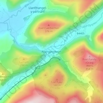
Name: Abergynolwyn topographic map, elevation, terrain.

Location: Abergynolwyn, Gwynedd, Wales, LL36 9YH, United Kingdom (52.62506 -3.97610 52.66506 -3.93610)

Average elevation: 614 ft

Minimum elevation: 36 ft

Maximum elevation: 1,588 ft

Other topographic maps

Click on a map to view its topography, its elevation and its terrain.

Llyn y Dywarchen

United Kingdom > Wales > Gwynedd > Rhyd-ddu

Average elevation: 856 ft

Betws Garmon

United Kingdom > Wales > Gwynedd

Average elevation: 935 ft

Llyn Cau

United Kingdom > Wales > Gwynedd

Average elevation: 1,821 ft

Gear up for your next adventure:

👖Convertible Hiking Pants - Versatile zip-off pants for changing altitudes and temperatures
🥄Camping Utensil Set - Lightweight utensils for outdoor meals
📌Outdoor GPS Map App - Apps and devices for digital topographic navigation
🪑Ultralight Camp Chairs - Portable seating for resting after a long day of mapping
💧Water Filtration Bottles - Safely drink from streams and lakes while exploring

As an Amazon Associate, this site earns from qualifying purchases at no extra cost to you.