
Make a donation
Gear up for your next adventure:
As an Amazon Associate, this site earns from qualifying purchases at no extra cost to you.
Campeche Island topographic map
Click on the map to display elevation.
Make a donation
Gear up for your next adventure:
As an Amazon Associate, this site earns from qualifying purchases at no extra cost to you.
About this map
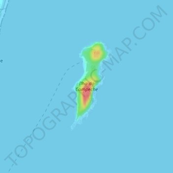
Name: Campeche Island topographic map, elevation, terrain.
Location: Campeche Island, Santa Catarina, South Region, Brazil (-27.70482 -48.46852 -27.69091 -48.46089)
Average elevation: 3 ft
Minimum elevation: 0 ft
Maximum elevation: 220 ft
Make a donation
Gear up for your next adventure:
As an Amazon Associate, this site earns from qualifying purchases at no extra cost to you.
Other topographic maps
Click on a map to view its topography, its elevation and its terrain.
Cachoeira do Tabuleiro
Brazil > Santa Catarina > Santo Amaro da Imperatriz
Average elevation: 3,002 ft
Make a donation
Gear up for your next adventure:
As an Amazon Associate, this site earns from qualifying purchases at no extra cost to you.