
Barrage el Kebir topographic map
Interactive map
Click on the map to display elevation.
About this map
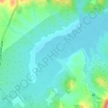
Name: Barrage el Kebir topographic map, elevation, terrain.
Location: Barrage el Kebir, RN 4 طو, Eddroua, El Fahs, Zaghouan, Tunisie (36.22651 9.75607 36.25304 9.79411)
Average elevation: 1,178 ft
Minimum elevation: 1,093 ft
Maximum elevation: 1,529 ft
Other topographic maps
Click on a map to view its topography, its elevation and its terrain.
Djebel Zaghouan
Djebel Zaghouan, Bir Halima, Zaghouan, Tunisie
Average elevation: 2,493 ft
Bir Mcherga
Tunisie > Zaghouan > Bir Mcherga
Bir Mcherga, Bir M'chergua, Bir Mchergua, Zaghouan, 1141, Tunisie
Average elevation: 512 ft
Barrage de Errmal
Barrage de Errmal, RR 35 طج, Bouachir, Bou Achir, Ez-Zeriba, Zaghouan, Tunisie
Average elevation: 180 ft