Geolocate

Burch topographic map

Click on the map to display elevation.

About this map

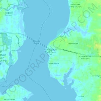
Name: Burch topographic map, elevation, terrain.

Location: Burch, Calvert County, Maryland, 20612, United States (38.48929 -76.68218 38.52929 -76.64218)

Average elevation: 10 ft

Minimum elevation: -13 ft

Maximum elevation: 49 ft

Calvert County trails, hiking, mountain biking, running and outdoor activities

Other topographic maps

Click on a map to view its topography, its elevation and its terrain.

Dunkirk

United States > Maryland > Calvert County

Average elevation: 85 ft

North Beach

United States > Maryland > Calvert County

Average elevation: 16 ft

Calvert Cliffs

United States > Maryland > Calvert County

Average elevation: 36 ft

Gear up for your next adventure:

🌡️Handheld Weather Meters - Measure wind, temp, and pressure for safe mountain travel
💧Water Filtration Bottles - Safely drink from streams and lakes while exploring
📡GPS Antenna Upgrade - Enhance GPS reception in remote terrain
🛰️Handheld GPS Units - Professional satellite navigators for precise backcountry mapping
🕶️GPS Smartphone Mount - Secure mount for phone navigation

As an Amazon Associate, this site earns from qualifying purchases at no extra cost to you.