Geolocate

Chian topographic map

Click on the map to display elevation.

About this map

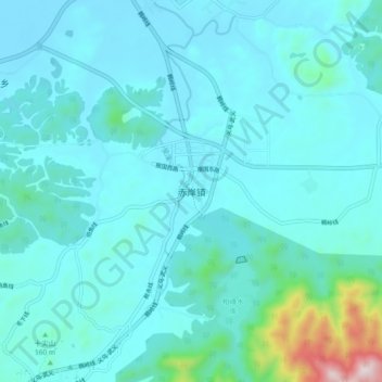
Name: Chian topographic map, elevation, terrain.

Location: Chian, Jinhua, Zhejiang, China (29.10653 119.99006 29.18653 120.07006)

Average elevation: 427 ft

Minimum elevation: 171 ft

Maximum elevation: 2,474 ft

Gear up for your next adventure:

🛰️Satellite Messengers - Emergency SOS and two-way messaging for off-grid adventures
🎒Outdoor Daypacks - Lightweight backpacks designed for carrying maps and essential gear
🦶Carbon Trekking Poles - Reduce knee impact on steep descents with ultra-light poles
🌲Outdoor Survival Books - Best books on survival skills
🌐World Map Poster - Decorative world maps with topographic info

As an Amazon Associate, this site earns from qualifying purchases at no extra cost to you.