
Pessegueiro topographic map
Interactive map
Click on the map to display elevation.
About this map
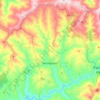
Name: Pessegueiro topographic map, elevation, terrain.
Location: Pessegueiro, Pampilhosa da Serra, Coïmbre, Portugal (40.01636 -8.06098 40.11468 -7.99030)
Average elevation: 2,024 ft
Minimum elevation: 961 ft
Maximum elevation: 3,363 ft
Other topographic maps
Click on a map to view its topography, its elevation and its terrain.
Meãs
Portugal > Coïmbre > Pampilhosa da Serra
Meãs, Unhais-o-Velho, Pampilhosa da Serra, Coïmbre, Portugal
Average elevation: 2,812 ft
Cabril
Portugal > Coïmbre > Pampilhosa da Serra
Cabril, Pampilhosa da Serra, Coïmbre, Portugal
Average elevation: 2,231 ft