
Cabril topographic map
Interactive map
Click on the map to display elevation.
About this map
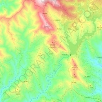
Name: Cabril topographic map, elevation, terrain.
Location: Cabril, Pampilhosa da Serra, Coïmbre, Portugal (40.04737 -7.93142 40.13870 -7.85278)
Average elevation: 2,231 ft
Minimum elevation: 1,302 ft
Maximum elevation: 3,783 ft
Other topographic maps
Click on a map to view its topography, its elevation and its terrain.
Pessegueiro
Portugal > Coïmbre > Pampilhosa da Serra
Pessegueiro, Pampilhosa da Serra, Coïmbre, Portugal
Average elevation: 2,024 ft
Meãs
Portugal > Coïmbre > Pampilhosa da Serra
Meãs, Unhais-o-Velho, Pampilhosa da Serra, Coïmbre, Portugal
Average elevation: 2,812 ft