
Thank you for supporting this site ❤️
Make a donation
Make a donation
Gear up for your next adventure:
As an Amazon Associate, this site earns from qualifying purchases at no extra cost to you.
Abelo topographic map
Click on the map to display elevation.
Thank you for supporting this site ❤️
Make a donation
Make a donation
Gear up for your next adventure:
As an Amazon Associate, this site earns from qualifying purchases at no extra cost to you.
About this map
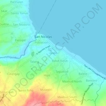
Name: Abelo topographic map, elevation, terrain.
Location: Abelo, San Nicolas, Batangas, Calabarzon, 4207, Philippines (13.90372 120.93604 13.94372 120.97604)
Average elevation: 89 ft
Minimum elevation: 10 ft
Maximum elevation: 351 ft
Thank you for supporting this site ❤️
Make a donation
Make a donation
Gear up for your next adventure:
As an Amazon Associate, this site earns from qualifying purchases at no extra cost to you.