Geolocate

Port Kelley topographic map

Click on the map to display elevation.

About this map

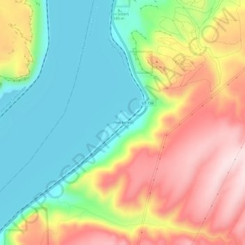
Name: Port Kelley topographic map, elevation, terrain.

Location: Port Kelley, Walla Walla County, Washington, United States (46.00541 -118.95806 46.04541 -118.91806)

Average elevation: 837 ft

Minimum elevation: 315 ft

Maximum elevation: 1,545 ft

Walla Walla County trails, hiking, mountain biking, running and outdoor activities

Other topographic maps

Click on a map to view its topography, its elevation and its terrain.

Walla Walla

United States > Washington > Walla Walla County

Walla Walla County features a varied topography characterized by rolling hills, valleys, and river systems. The elevation in the area averages around 940 feet (approximately 287 meters) above sea level, with some areas rising to nearly 1,200 feet. The landscape is shaped by the Walla Walla River, which carves…

Average elevation: 974 ft

Burbank

United States > Washington > Walla Walla County > Burbank

Average elevation: 377 ft

Wallula

United States > Washington > Walla Walla County

Average elevation: 390 ft

Waitsburg

United States > Washington > Walla Walla County

Average elevation: 1,358 ft

Dixie

United States > Washington > Walla Walla County > Dixie

Average elevation: 1,762 ft

Gear up for your next adventure:

🧴Hand Sanitizer - Keep hands clean while hiking
🛡️Insect Repellent - Protection against bugs during outdoor activities
🛠️Backpacking Tool Kit - Essential toolkit for outdoor repairs
🧭Hiking Compass - Precision compass for reliable navigation in the wilderness
📡GPS Antenna Upgrade - Enhance GPS reception in remote terrain

As an Amazon Associate, this site earns from qualifying purchases at no extra cost to you.