Geolocate

Washington topographic map

Click on the map to display elevation.

About this map

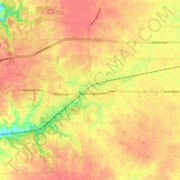
Name: Washington topographic map, elevation, terrain.

Location: Washington, Tazewell County, Illinois, 61571, United States (40.67512 -89.48370 40.73474 -89.37796)

Average elevation: 774 ft

Minimum elevation: 640 ft

Maximum elevation: 833 ft

Tazewell County trails, hiking, mountain biking, running and outdoor activities

Other topographic maps

Click on a map to view its topography, its elevation and its terrain.

Allentown

United States > Illinois > Tazewell County

Average elevation: 673 ft

Groveland

United States > Illinois > Tazewell County

Average elevation: 745 ft

Brock Lake

United States > Illinois > Tazewell County > Mackinaw

Average elevation: 617 ft

Gear up for your next adventure:

🦶Hiking Gaiters - Keep debris and water out of your boots
🪶Paracord Bracelet - Survival bracelet with built‑in tools
🪶Fire Starter Kit - Reliable fire starter for survival and camping
🔭Compact Binoculars - HD vision for scouting terrain and identifying distant landmarks
🧭GPS Watch Accessories - Bands and chargers for GPS watches

As an Amazon Associate, this site earns from qualifying purchases at no extra cost to you.