Geolocate

Quipot topographic map

Click on the map to display elevation.

About this map

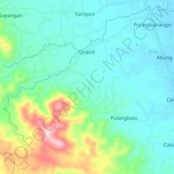
Name: Quipot topographic map, elevation, terrain.

Location: Quipot, San Juan, Batangas, Calabarzon, Philippines (13.73198 121.34056 13.78324 121.40571)

Average elevation: 348 ft

Minimum elevation: 33 ft

Maximum elevation: 1,424 ft

Other topographic maps

Click on a map to view its topography, its elevation and its terrain.

Lawaye

Philippines > Batangas > San Juan > Pinagbayanan

Average elevation: 16 ft

Bulihan

Philippines > Batangas > San Juan > Janaojanao > Bulihan

Average elevation: 72 ft

Gear up for your next adventure:

Camping Coffee Makers - Enjoy premium coffee at the summit or campsite
🧭Hiking Compass - Precision compass for reliable navigation in the wilderness
🪶Paracord Bracelet - Survival bracelet with built‑in tools
🧭Compass with Lanyard - Easy‑carry compass for navigation
🔋Solar Power Banks - Keep your GPS and phone charged in remote wilderness areas

As an Amazon Associate, this site earns from qualifying purchases at no extra cost to you.