Geolocate

Siruma topographic map

Click on the map to display elevation.

About this map

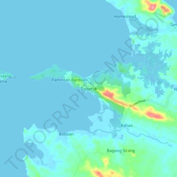
Name: Siruma topographic map, elevation, terrain.

Location: Siruma, Camarines Sur, Bicol Region, Philippines (13.98056 123.21867 14.06056 123.29867)

Average elevation: 30 ft

Minimum elevation: -20 ft

Maximum elevation: 335 ft

Other topographic maps

Click on a map to view its topography, its elevation and its terrain.

Del Gallego

Philippines > Camarines Sur

Average elevation: 299 ft

Sagñay

Philippines > Camarines Sur

Average elevation: 535 ft

Caramoan

Philippines > Camarines Sur

Average elevation: 138 ft

Gear up for your next adventure:

🛡️Insect Repellent - Protection against bugs during outdoor activities
🌎3D Topographic Globes - Raised relief globes for a tactile understanding of geography
🪑Ultralight Camp Chairs - Portable seating for resting after a long day of mapping
💧Water Purification System - Clean water on the trail with reliable purifiers
📚Navigation Handbooks - Master the art of reading topographic maps and using a compass

As an Amazon Associate, this site earns from qualifying purchases at no extra cost to you.