
Make a donation
Gear up for your next adventure:
As an Amazon Associate, this site earns from qualifying purchases at no extra cost to you.
Sankt Annen topographic map
Click on the map to display elevation.
Make a donation
Gear up for your next adventure:
As an Amazon Associate, this site earns from qualifying purchases at no extra cost to you.
About this map
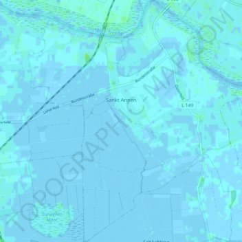
Name: Sankt Annen topographic map, elevation, terrain.
Average elevation: 0 ft
Minimum elevation: -10 ft
Maximum elevation: 26 ft
Make a donation
Gear up for your next adventure:
As an Amazon Associate, this site earns from qualifying purchases at no extra cost to you.
Other topographic maps
Click on a map to view its topography, its elevation and its terrain.
Make a donation
Gear up for your next adventure:
As an Amazon Associate, this site earns from qualifying purchases at no extra cost to you.
WKK Ententeich
Deutschland > Schleswig-Holstein > Dithmarschen > Heide > Hochfeld
Average elevation: 26 ft
Make a donation
Gear up for your next adventure:
As an Amazon Associate, this site earns from qualifying purchases at no extra cost to you.
Make a donation
Gear up for your next adventure:
As an Amazon Associate, this site earns from qualifying purchases at no extra cost to you.
Zippelkoog
Deutschland > Schleswig-Holstein > Dithmarschen > Helse > Zippelkoog
Average elevation: 3 ft
Make a donation
Gear up for your next adventure:
As an Amazon Associate, this site earns from qualifying purchases at no extra cost to you.
Poppenwurth
Deutschland > Schleswig-Holstein > Dithmarschen > Oesterwurth > Poppenwurth
Average elevation: 7 ft
Make a donation
Gear up for your next adventure:
As an Amazon Associate, this site earns from qualifying purchases at no extra cost to you.
Oldörpen
Deutschland > Schleswig-Holstein > Dithmarschen > Tensbüttel-Röst > Tensbüttel > Oldörpen
Average elevation: 56 ft