
Make a donation
Gear up for your next adventure:
As an Amazon Associate, this site earns from qualifying purchases at no extra cost to you.
Solferino topographic map
Click on the map to display elevation.
Make a donation
Gear up for your next adventure:
As an Amazon Associate, this site earns from qualifying purchases at no extra cost to you.
Solferino
The municipal territory, extending for 13.08 km2, is part of the Morainic amphitheatre of Lake Garda, located a few kilometres to the north. The altitude at the town hall is 124 m above sea level. Not far away also lies the province of Verona, with the towns of Peschiera del Garda and Valeggio sul Mincio, only a few kilometres to the east.
Make a donation
Gear up for your next adventure:
As an Amazon Associate, this site earns from qualifying purchases at no extra cost to you.
About this map
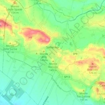
Name: Solferino topographic map, elevation, terrain.
Location: Solferino, Mantua, Lombardy, 46040, Italy (45.34248 10.53443 45.38982 10.58191)
Average elevation: 390 ft
Minimum elevation: 253 ft
Maximum elevation: 650 ft
Make a donation
Gear up for your next adventure:
As an Amazon Associate, this site earns from qualifying purchases at no extra cost to you.
Other topographic maps
Click on a map to view its topography, its elevation and its terrain.
Make a donation
Gear up for your next adventure:
As an Amazon Associate, this site earns from qualifying purchases at no extra cost to you.
Forte di Pietole
Italy > Lombardy > Mantua > Borgo Virgilio > Pietole > Pietole Vecchia
Average elevation: 62 ft