
Make a donation
Gear up for your next adventure:
As an Amazon Associate, this site earns from qualifying purchases at no extra cost to you.
Sedibeng District Municipality topographic map
Click on the map to display elevation.
Make a donation
Gear up for your next adventure:
As an Amazon Associate, this site earns from qualifying purchases at no extra cost to you.
About this map
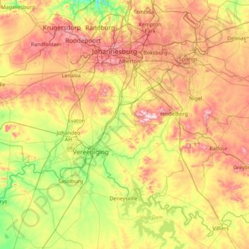
Name: Sedibeng District Municipality topographic map, elevation, terrain.
Location: Sedibeng District Municipality, Gauteng, South Africa (-26.92383 27.56909 -26.17224 28.86129)
Average elevation: 5,098 ft
Minimum elevation: 4,416 ft
Maximum elevation: 6,240 ft
Make a donation
Gear up for your next adventure:
As an Amazon Associate, this site earns from qualifying purchases at no extra cost to you.
Other topographic maps
Click on a map to view its topography, its elevation and its terrain.
Pretoria
South Africa > Gauteng > City of Tshwane Metropolitan Municipality
Pretoria is situated approximately 55 km (34 mi) north-northeast of Johannesburg in the northeast of South Africa, in a transitional belt between the plateau of the Highveld to the south and the lower-lying Bushveld to the north. It lies at an altitude of about 1,339 m (4,393 ft) above sea level, in a warm,…
Average elevation: 4,472 ft
Johannesburg
South Africa > Gauteng > City of Johannesburg Metropolitan Municipality
Johannesburg is located in the eastern plateau area of South Africa known as the Highveld, at an elevation of 1,753 metres (5,751 ft). The former Central Business District is located on the southern side of the prominent ridge called the Witwatersrand (English: White Water's Ridge) and the terrain falls to the…
Average elevation: 5,299 ft
Soweto
South Africa > Gauteng > City of Johannesburg Metropolitan Municipality
Average elevation: 5,374 ft
Mamelodi
South Africa > Gauteng > City of Tshwane Metropolitan Municipality
Average elevation: 4,327 ft
Make a donation
Gear up for your next adventure:
As an Amazon Associate, this site earns from qualifying purchases at no extra cost to you.
Kempton Park
South Africa > Gauteng > City of Ekurhuleni Metropolitan Municipality
Average elevation: 5,427 ft
Johannesburg
South Africa > Gauteng > City of Johannesburg Metropolitan Municipality
Johannesburg is located in the eastern plateau area of South Africa known as the Highveld, at an elevation of 1,753 metres (5,751 ft). The former Central Business District is located on the southern side of the prominent ridge called the Witwatersrand (English: White Water's Ridge) and the terrain falls to the…
Average elevation: 5,299 ft
Springs
South Africa > Gauteng > City of Ekurhuleni Metropolitan Municipality
Average elevation: 5,269 ft
Thembisa
South Africa > Gauteng > City of Ekurhuleni Metropolitan Municipality
Average elevation: 5,230 ft
Make a donation
Gear up for your next adventure:
As an Amazon Associate, this site earns from qualifying purchases at no extra cost to you.
Pretoria
South Africa > Gauteng > City of Tshwane Metropolitan Municipality
Pretoria is situated approximately 55 km (34 mi) north-northeast of Johannesburg in the northeast of South Africa, in a transitional belt between the plateau of the Highveld to the south and the lower-lying Bushveld to the north. It lies at an altitude of about 1,339 m (4,393 ft) above sea level, in a warm,…
Average elevation: 4,472 ft
Tshepisong
South Africa > Gauteng > City of Johannesburg Metropolitan Municipality
Average elevation: 5,505 ft
Midrand
South Africa > Gauteng > City of Johannesburg Metropolitan Municipality
Average elevation: 5,059 ft
Roodepoort
South Africa > Gauteng > City of Johannesburg Metropolitan Municipality
Average elevation: 5,226 ft
Make a donation
Gear up for your next adventure:
As an Amazon Associate, this site earns from qualifying purchases at no extra cost to you.
Nigel
South Africa > Gauteng > City of Ekurhuleni Metropolitan Municipality
Average elevation: 5,151 ft
Soweto
South Africa > Gauteng > City of Johannesburg Metropolitan Municipality
Average elevation: 5,374 ft
Benoni
South Africa > Gauteng > City of Ekurhuleni Metropolitan Municipality
Average elevation: 5,397 ft
Sebokeng
South Africa > Gauteng > Sedibeng District Municipality > Emfuleni Local Municipality
Average elevation: 4,997 ft
Make a donation
Gear up for your next adventure:
As an Amazon Associate, this site earns from qualifying purchases at no extra cost to you.
Daveyton
South Africa > Gauteng > City of Ekurhuleni Metropolitan Municipality
Average elevation: 5,292 ft
Danville
South Africa > Gauteng > City of Tshwane Metropolitan Municipality > Pretoria
Average elevation: 4,432 ft
Centurion
South Africa > Gauteng > City of Tshwane Metropolitan Municipality
Average elevation: 4,760 ft
Meyerton
South Africa > Gauteng > Sedibeng District Municipality > Midvaal Local Municipality
Average elevation: 4,852 ft
Make a donation
Gear up for your next adventure:
As an Amazon Associate, this site earns from qualifying purchases at no extra cost to you.
City of Johannesburg Metropolitan Municipality
South Africa > Gauteng > City of Johannesburg Metropolitan Municipality
Average elevation: 5,299 ft
Etwatwa
South Africa > Gauteng > City of Ekurhuleni Metropolitan Municipality
Average elevation: 5,285 ft
Boksburg
South Africa > Gauteng > City of Ekurhuleni Metropolitan Municipality
Average elevation: 5,371 ft
Randburg
South Africa > Gauteng > City of Johannesburg Metropolitan Municipality
Average elevation: 5,141 ft
Make a donation
Gear up for your next adventure:
As an Amazon Associate, this site earns from qualifying purchases at no extra cost to you.
Alberton
South Africa > Gauteng > City of Ekurhuleni Metropolitan Municipality
Alberton lies at an elevation of approximately 1,570 m (5,150 ft) above sea level on the banks of the Natal Spruit, approximately 11 km south-east of Johannesburg CBD, 59 km south of Pretoria and 49 km north-east of Vereeniging. Organisationally and administratively, it is included in the City of Ekurhuleni…
Average elevation: 5,305 ft
Germiston
South Africa > Gauteng > City of Ekurhuleni Metropolitan Municipality
Average elevation: 5,364 ft
Sandton
South Africa > Gauteng > City of Johannesburg Metropolitan Municipality
Average elevation: 5,194 ft
Make a donation
Gear up for your next adventure:
As an Amazon Associate, this site earns from qualifying purchases at no extra cost to you.
Lenasia
South Africa > Gauteng > City of Johannesburg Metropolitan Municipality
Average elevation: 5,217 ft
Randburg
South Africa > Gauteng > City of Johannesburg Metropolitan Municipality
Average elevation: 5,141 ft
Springs
South Africa > Gauteng > City of Ekurhuleni Metropolitan Municipality
Average elevation: 5,269 ft
Make a donation
Gear up for your next adventure:
As an Amazon Associate, this site earns from qualifying purchases at no extra cost to you.
Sharpeville
South Africa > Gauteng > Sedibeng District Municipality > Emfuleni Local Municipality
Average elevation: 4,787 ft
Bass Lake
South Africa > Gauteng > Sedibeng District Municipality > Midvaal Local Municipality
Average elevation: 4,833 ft
Evaton
South Africa > Gauteng > Sedibeng District Municipality > Emfuleni Local Municipality
Average elevation: 4,993 ft
Sebokeng
South Africa > Gauteng > Sedibeng District Municipality > Emfuleni Local Municipality
Average elevation: 4,997 ft
Make a donation
Gear up for your next adventure:
As an Amazon Associate, this site earns from qualifying purchases at no extra cost to you.
Magaliesberg Biosphere Reserve
The reserve includes a variety of landscapes including slopes, cliffs, crests, kloofs, rivers, wetlands and valleys. Although the area covers a diverse geological area, it consists mainly of the Magaliesberg mountain complex comprising two geological formations: the Transvaal System and the Bushveld Igneous…
Average elevation: 4,482 ft
Magaliesburg
South Africa > Gauteng > West Rand District Municipality > Mogale City Local Municipality
Average elevation: 4,934 ft
Johannesburg
South Africa > Gauteng > City of Johannesburg Metropolitan Municipality
Johannesburg is located in the eastern plateau area of South Africa known as the Highveld, at an elevation of 1,753 metres (5,751 ft). The former Central Business District is located on the southern side of the prominent ridge called the Witwatersrand (English: White Water's Ridge) and the terrain falls to the…
Average elevation: 5,299 ft
Vanderbijlpark
South Africa > Gauteng > Sedibeng District Municipality > Emfuleni Local Municipality
Vanderbijlpark is situated on the highveld of South Africa, at an altitude of 1,500 meters on the banks of the Vaal River. Summers in the city are warm to hot with an average high between 31 and 35°C, and an average low between 15 and 22°C. Winters in the city are cool to warm with an average high of between…
Average elevation: 4,836 ft
Make a donation
Gear up for your next adventure:
As an Amazon Associate, this site earns from qualifying purchases at no extra cost to you.
Emmarentia Dam
South Africa > Gauteng > City of Johannesburg Metropolitan Municipality > Johannesburg
Average elevation: 5,285 ft
Thembisa
South Africa > Gauteng > City of Ekurhuleni Metropolitan Municipality
Average elevation: 5,230 ft
Ennerdale
South Africa > Gauteng > City of Johannesburg Metropolitan Municipality
Average elevation: 5,348 ft
Carletonville
South Africa > Gauteng > West Rand District Municipality > Merafong City Local Municipality
Average elevation: 5,049 ft
Make a donation
Gear up for your next adventure:
As an Amazon Associate, this site earns from qualifying purchases at no extra cost to you.
Tshepisong
South Africa > Gauteng > City of Johannesburg Metropolitan Municipality
Average elevation: 5,505 ft
Ga-Rankuwa
South Africa > Gauteng > City of Tshwane Metropolitan Municipality
Average elevation: 4,026 ft
Magaliesburg
South Africa > Gauteng > West Rand District Municipality > Mogale City Local Municipality
Average elevation: 4,934 ft
Make a donation
Gear up for your next adventure:
As an Amazon Associate, this site earns from qualifying purchases at no extra cost to you.
Bronkhorstspruit
South Africa > Gauteng > City of Tshwane Metropolitan Municipality
Average elevation: 4,629 ft
Cullinan
South Africa > Gauteng > City of Tshwane Metropolitan Municipality
Cullinan is situated in the Highveld region of South Africa. The town has an elevation of 1476 m (4842.52 ft) and is located at −25.6709 [latitude in decimal degrees], 28.5236 [longitude in decimal degrees]. The closest city is Pretoria being 40 km (25 mi) away, while Johannesburg is 100 km (62 mi) away.
Average elevation: 4,659 ft
Randfontein
South Africa > Gauteng > West Rand District Municipality > Randfontein Local Municipality
As of 2011, Randfontein has a population of 149,286, which incorporates Mohlakeng and Toekomsrus. (In 2001, the population was 128,731.) The average elevation of the town is 1709m above sea level. The total municipal area, after recent restructuring, is 475 km2 (183 sq mi).
Average elevation: 5,581 ft
Brakpan
South Africa > Gauteng > City of Ekurhuleni Metropolitan Municipality
Average elevation: 5,328 ft
Make a donation
Gear up for your next adventure:
As an Amazon Associate, this site earns from qualifying purchases at no extra cost to you.
Klipriviersberg Nature Reserve
South Africa > Gauteng > City of Johannesburg Metropolitan Municipality > Johannesburg
Average elevation: 5,361 ft
Delta Park
South Africa > Gauteng > City of Johannesburg Metropolitan Municipality > Rosebank
Average elevation: 5,210 ft
Daveyton
South Africa > Gauteng > City of Ekurhuleni Metropolitan Municipality
Average elevation: 5,292 ft
Emmarentia Dog Park
South Africa > Gauteng > City of Johannesburg Metropolitan Municipality > Johannesburg
Average elevation: 5,384 ft
Make a donation
Gear up for your next adventure:
As an Amazon Associate, this site earns from qualifying purchases at no extra cost to you.
iKhaya LamaDube Lodge
South Africa > Gauteng > City of Tshwane Metropolitan Municipality
Average elevation: 3,760 ft
Rosebank
South Africa > Gauteng > City of Johannesburg Metropolitan Municipality
Average elevation: 5,374 ft
Zoo Lake
South Africa > Gauteng > City of Johannesburg Metropolitan Municipality > Rosebank
Average elevation: 5,404 ft
Suikerbosrand Nature Reserve
South Africa > Gauteng > Sedibeng District Municipality > Lesedi Local Municipality
Suikerbosrand Nature Reserve is a protected area which encompasses most of the Suikerbosrand Range, South Africa. It is one of Gauteng's most frequented ecotourism locations, located approximately 50 kilometres south-east of Johannesburg, just west of the town of Heidelberg in the upper catchment of the Klip…
Average elevation: 5,305 ft
Make a donation
Gear up for your next adventure:
As an Amazon Associate, this site earns from qualifying purchases at no extra cost to you.
De Deur
South Africa > Gauteng > Sedibeng District Municipality > Midvaal Local Municipality
Average elevation: 5,075 ft
Thokoza Park
South Africa > Gauteng > City of Johannesburg Metropolitan Municipality > Soweto
Average elevation: 5,262 ft
Leratong Village
South Africa > Gauteng > City of Johannesburg Metropolitan Municipality
Average elevation: 5,538 ft
Make a donation
Gear up for your next adventure:
As an Amazon Associate, this site earns from qualifying purchases at no extra cost to you.
Cooper's Cave
South Africa > Gauteng > West Rand District Municipality > Krugersdorp
Average elevation: 4,852 ft
Roodepoort
South Africa > Gauteng > City of Johannesburg Metropolitan Municipality
Average elevation: 5,289 ft
Bill Stewart Nature Reserve
South Africa > Gauteng > City of Ekurhuleni Metropolitan Municipality
Average elevation: 5,561 ft
Coronation Park
South Africa > Gauteng > West Rand District Municipality > Krugersdorp
Average elevation: 5,699 ft
Make a donation
Gear up for your next adventure:
As an Amazon Associate, this site earns from qualifying purchases at no extra cost to you.
Boipatong
South Africa > Gauteng > Sedibeng District Municipality > Emfuleni Local Municipality
Average elevation: 4,849 ft
Blaaupan Dam
South Africa > Gauteng > City of Ekurhuleni Metropolitan Municipality
Average elevation: 5,433 ft
Centurion Lake
South Africa > Gauteng > City of Tshwane Metropolitan Municipality > Centurion
Average elevation: 4,724 ft
Roodeplaat Dam
South Africa > Gauteng > City of Tshwane Metropolitan Municipality
Average elevation: 3,983 ft
Make a donation
Gear up for your next adventure:
As an Amazon Associate, this site earns from qualifying purchases at no extra cost to you.
Modderfontein
South Africa > Gauteng > Sedibeng District Municipality > Midvaal Local Municipality
Average elevation: 5,033 ft
Unaville AH
South Africa > Gauteng > City of Johannesburg Metropolitan Municipality
Average elevation: 5,312 ft
George Hay Park
South Africa > Gauteng > City of Johannesburg Metropolitan Municipality > Johannesburg
Average elevation: 5,407 ft
Johannesburg Botanical Gardens
South Africa > Gauteng > City of Johannesburg Metropolitan Municipality > Johannesburg
Average elevation: 5,358 ft
Make a donation
Gear up for your next adventure:
As an Amazon Associate, this site earns from qualifying purchases at no extra cost to you.
Emmarentia Fountain
South Africa > Gauteng > City of Johannesburg Metropolitan Municipality > Johannesburg
Average elevation: 5,289 ft
Morula View Park
South Africa > Gauteng > City of Tshwane Metropolitan Municipality
Average elevation: 3,940 ft
Jukskei Park
South Africa > Gauteng > City of Johannesburg Metropolitan Municipality > Randburg
Average elevation: 4,682 ft
Make a donation
Gear up for your next adventure:
As an Amazon Associate, this site earns from qualifying purchases at no extra cost to you.
Wierda Glen
South Africa > Gauteng > City of Tshwane Metropolitan Municipality > Simarlo AH
Average elevation: 4,852 ft
Victory Park
South Africa > Gauteng > City of Johannesburg Metropolitan Municipality > Johannesburg
Average elevation: 5,240 ft
Thokoza Park
South Africa > Gauteng > City of Johannesburg Metropolitan Municipality > Soweto
Average elevation: 5,262 ft
Thembisa
South Africa > Gauteng > City of Ekurhuleni Metropolitan Municipality
Average elevation: 5,230 ft
Make a donation
Gear up for your next adventure:
As an Amazon Associate, this site earns from qualifying purchases at no extra cost to you.
Ga-Rankuwa
South Africa > Gauteng > City of Tshwane Metropolitan Municipality
Average elevation: 4,026 ft
Muldersdrift
South Africa > Gauteng > West Rand District Municipality > Mogale City Local Municipality
Average elevation: 4,754 ft
Kew
South Africa > Gauteng > City of Johannesburg Metropolitan Municipality
Average elevation: 5,253 ft
Diepsloot
South Africa > Gauteng > City of Johannesburg Metropolitan Municipality > Diepsloot
Average elevation: 4,616 ft
Make a donation
Gear up for your next adventure:
As an Amazon Associate, this site earns from qualifying purchases at no extra cost to you.
Soweto
South Africa > Gauteng > City of Johannesburg Metropolitan Municipality
Average elevation: 5,374 ft
Mamelodi
South Africa > Gauteng > City of Tshwane Metropolitan Municipality
Average elevation: 4,327 ft
Klip River
South Africa > Gauteng > City of Johannesburg Metropolitan Municipality
Average elevation: 5,036 ft
Germiston
South Africa > Gauteng > City of Ekurhuleni Metropolitan Municipality
Average elevation: 5,364 ft
Make a donation
Gear up for your next adventure:
As an Amazon Associate, this site earns from qualifying purchases at no extra cost to you.
Pretoria
South Africa > Gauteng > City of Tshwane Metropolitan Municipality
Pretoria is situated approximately 56 km (35 mi) north-northeast of Johannesburg in the northeast of South Africa, in a transitional belt between the plateau of the Highveld to the south and the lower-lying Bushveld to the north. It lies at an altitude of about 1,339 m (4,393 ft) above sea level, in a warm,…
Average elevation: 4,472 ft
Daveyton
South Africa > Gauteng > City of Ekurhuleni Metropolitan Municipality
Average elevation: 5,292 ft
Thembisa
South Africa > Gauteng > City of Ekurhuleni Metropolitan Municipality
Average elevation: 5,230 ft
Lenasia
South Africa > Gauteng > City of Johannesburg Metropolitan Municipality
Average elevation: 5,217 ft
Make a donation
Gear up for your next adventure:
As an Amazon Associate, this site earns from qualifying purchases at no extra cost to you.
Soweto
South Africa > Gauteng > City of Johannesburg Metropolitan Municipality
Average elevation: 5,374 ft
Mamelodi
South Africa > Gauteng > City of Tshwane Metropolitan Municipality
Average elevation: 4,327 ft
Ennerdale
South Africa > Gauteng > City of Johannesburg Metropolitan Municipality
Average elevation: 5,348 ft
Make a donation
Gear up for your next adventure:
As an Amazon Associate, this site earns from qualifying purchases at no extra cost to you.