Geolocate

Perez topographic map

Click on the map to display elevation.

About this map

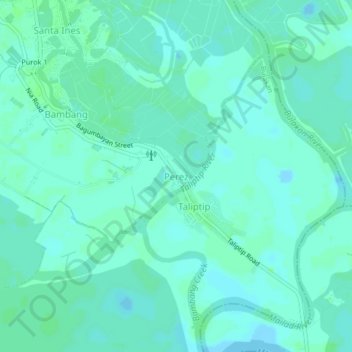
Name: Perez topographic map, elevation, terrain.

Location: Perez, Bulakan, Bulacan, Central Luzon, 3017, Philippines (14.74925 120.87512 14.78925 120.91512)

Average elevation: 10 ft

Minimum elevation: -10 ft

Maximum elevation: 20 ft

Other topographic maps

Click on a map to view its topography, its elevation and its terrain.

Taliptip

Philippines > Bulacan > Bulakan

Average elevation: 10 ft

Malolos River

Philippines > Bulacan > Bulakan > Babatnin

Average elevation: 10 ft

Taliptip

Philippines > Bulacan > Bulakan

Average elevation: 10 ft

Capiz River

Philippines > Bulacan > Bulakan

Average elevation: 13 ft

Gear up for your next adventure:

📱Solar Portable Charger - Solar power bank for charging devices off‑grid
Camping Coffee Makers - Enjoy premium coffee at the summit or campsite
🛠️Outdoor Gear Repair Kit - Essential tools to fix gear on the trail
🪶Thermal Camp Blanket - Extra warmth for cold nights
🧴Hand Sanitizer - Keep hands clean while hiking

As an Amazon Associate, this site earns from qualifying purchases at no extra cost to you.