
Juan Martín de Pueyrredón topographic map
Interactive map
Click on the map to display elevation.
About this map
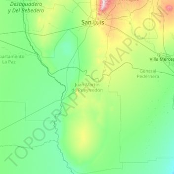
Name: Juan Martín de Pueyrredón topographic map, elevation, terrain.
Location: Juan Martín de Pueyrredón, San Luis, Argentinien (-34.82438 -67.18498 -33.07913 -65.97522)
Average elevation: 1,775 ft
Minimum elevation: 1,093 ft
Maximum elevation: 7,192 ft
Other topographic maps
Click on a map to view its topography, its elevation and its terrain.
Cerro Nevado
Cerro Nevado, Belgrano, San Luis, Argentinien
Average elevation: 3,333 ft