Geolocate

Tifton topographic map

Click on the map to display elevation.

About this map

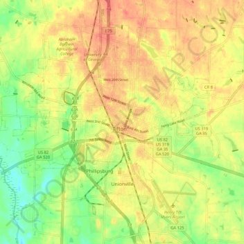
Name: Tifton topographic map, elevation, terrain.

Location: Tifton, Tift County, Georgia, 31794, United States (31.42190 -83.57666 31.49291 -83.47264)

Average elevation: 341 ft

Minimum elevation: 240 ft

Maximum elevation: 417 ft

Tift County trails, hiking, mountain biking, running and outdoor activities

Other topographic maps

Click on a map to view its topography, its elevation and its terrain.

Chula

United States > Georgia > Tift County

Average elevation: 361 ft

Chula

United States > Georgia > Tift County

Average elevation: 361 ft

Gear up for your next adventure:

🛰️Handheld GPS Units - Professional satellite navigators for precise backcountry mapping
🔋Rechargeable Batteries - Power up your outdoor devices
🧭Map Reading Tools - Tools and kits for map navigation
🦟Ultrasonic Repellers - Create a bug-free zone at your camp or rest stop
🥄Camping Utensil Set - Lightweight utensils for outdoor meals

As an Amazon Associate, this site earns from qualifying purchases at no extra cost to you.