
Thank you for supporting this site ❤️
Make a donation
Make a donation
Gear up for your next adventure:
As an Amazon Associate, this site earns from qualifying purchases at no extra cost to you.
Santa Maria Chiconautla topographic map
Click on the map to display elevation.
Thank you for supporting this site ❤️
Make a donation
Make a donation
Gear up for your next adventure:
As an Amazon Associate, this site earns from qualifying purchases at no extra cost to you.
About this map
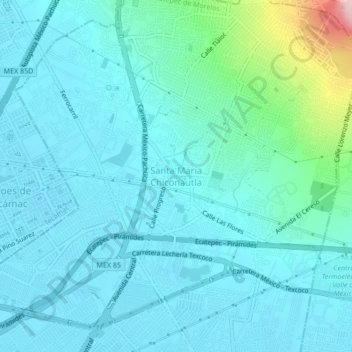
Name: Santa Maria Chiconautla topographic map, elevation, terrain.
Average elevation: 7,451 ft
Minimum elevation: 7,333 ft
Maximum elevation: 8,176 ft
Thank you for supporting this site ❤️
Make a donation
Make a donation
Gear up for your next adventure:
As an Amazon Associate, this site earns from qualifying purchases at no extra cost to you.
Other topographic maps
Click on a map to view its topography, its elevation and its terrain.
Deportivo Bicentenario "Siervo de la Nación"
México > Estado de México > Ecatepec de Morelos > Santa María Tulpetlac
Average elevation: 7,411 ft
Parque Bicentenario
México > Estado de México > Ecatepec de Morelos > San Andrés de la Cañada
Average elevation: 7,628 ft