
Calumet topographic map
Click on the map to display elevation.
Calumet
Calumet is at an elevation of 1,209 feet (369 m) above sea level. The village of Calumet sits on 2,000 miles (3,200 km) of underground mine shafts, drifts and stopes, empty for many decades. Large portions of the Keweenaw National Historical Park are located inside the village limits, mostly covering the intricate complex of the Calumet and Hecla Mining Company's main operations.
About this map
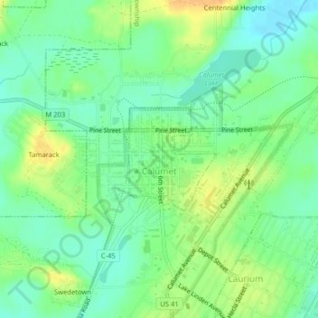
Name: Calumet topographic map, elevation, terrain.
Location: Calumet, Houghton County, Michigan, United States (47.24321 -88.45780 47.25197 -88.44689)
Average elevation: 1,211 ft
Minimum elevation: 1,165 ft
Maximum elevation: 1,273 ft
Houghton County trails, hiking, mountain biking, running and outdoor activities
Other topographic maps
Click on a map to view its topography, its elevation and its terrain.
Centennial Heights
United States > Michigan > Houghton County > Calumet Township
Average elevation: 1,194 ft
Limestone Mountain
United States > Michigan > Houghton County > Laird Township
Average elevation: 804 ft