Geolocate

Filadelfia topographic map

Click on the map to display elevation.

Filadelfia

Filadelfia has an area of 125.14 km² and an elevation of 17 metres.

Wikipedia (CC-BY-SA 3.0)

About this map

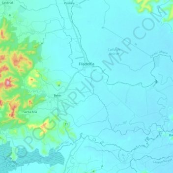
Name: Filadelfia topographic map, elevation, terrain.

Location: Filadelfia, Cantón Carrillo, Provincia Guanacaste, 50501, Costa Rica (10.36234 -85.57394 10.47563 -85.36877)

Average elevation: 125 ft

Minimum elevation: 13 ft

Maximum elevation: 1,371 ft

Other topographic maps

Click on a map to view its topography, its elevation and its terrain.

Playas del Coco

Costa Rica > Cantón Carrillo > Sardinal > El Coco

Average elevation: 131 ft

Playa Ocotal

Costa Rica > Cantón Carrillo > Sardinal > Ocotal

Average elevation: 131 ft

Gear up for your next adventure:

🔪Outdoor Multitools - Essential survival tools for gear repair and field use
🔌USB Car Charger - Car charger for on‑the‑go power needs
🧭Orienteering Set - Complete compass and map reading kit
🪶Camping Sleeping Pad - Comfortable sleeping pad for backpacking
☀️Outdoor Sunscreen - High protection sunscreen for outdoor activities

As an Amazon Associate, this site earns from qualifying purchases at no extra cost to you.