
Saint-Laurent-du-Maroni topographic map
Interactive map
Click on the map to display elevation.
About this map
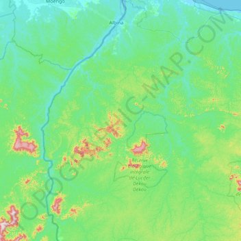
Name: Saint-Laurent-du-Maroni topographic map, elevation, terrain.
Location: Saint-Laurent-du-Maroni, Guiana Francesa, 97320, França (4.27148 -54.28179 5.62315 -53.73902)
Average elevation: 272 ft
Minimum elevation: -3 ft
Maximum elevation: 2,195 ft
Other topographic maps
Click on a map to view its topography, its elevation and its terrain.
Régina
França > Guiana Francesa > Régina
Régina, Cayenne, Guiana Francesa, França
Average elevation: 207 ft
Ouanary
França > Guiana Francesa > Ouanary
Ouanary, Cayenne, Guiana Francesa, 97380, França
Average elevation: 36 ft
Ilha do Diabo
Ilha do Diabo, Guiana Francesa, 97300, França
Average elevation: 3 ft