
Make a donation
Gear up for your next adventure:
As an Amazon Associate, this site earns from qualifying purchases at no extra cost to you.
Lake Lucerne topographic map
Click on the map to display elevation.
Make a donation
Gear up for your next adventure:
As an Amazon Associate, this site earns from qualifying purchases at no extra cost to you.
Lake Lucerne
The entire lake has a total area of 114 km² (44 sq mi) at an elevation of 434 m (1,424 ft) a.s.l., and a maximum depth of 214 m (702 ft). Its volume is 11.8 km³. Much of the shoreline rises steeply into mountains up to 1,500 m above the lake, resulting in many picturesque views including those of the mountains Rigi and Pilatus.
Make a donation
Gear up for your next adventure:
As an Amazon Associate, this site earns from qualifying purchases at no extra cost to you.
About this map
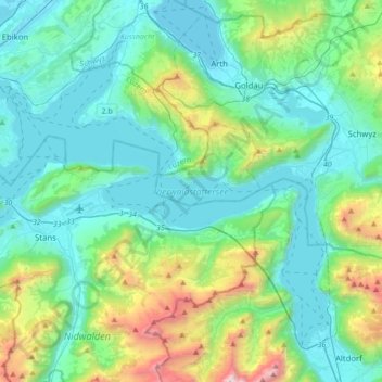
Name: Lake Lucerne topographic map, elevation, terrain.
Location: Lake Lucerne, Gersau, Schwyz, Switzerland (46.88869 8.27878 47.08219 8.62500)
Average elevation: 2,907 ft
Minimum elevation: 1,342 ft
Maximum elevation: 9,239 ft
Make a donation
Gear up for your next adventure:
As an Amazon Associate, this site earns from qualifying purchases at no extra cost to you.