
Thank you for supporting this site ❤️
Make a donation
Make a donation
Gear up for your next adventure:
As an Amazon Associate, this site earns from qualifying purchases at no extra cost to you.
Lägern topographic map
Click on the map to display elevation.
Thank you for supporting this site ❤️
Make a donation
Make a donation
Gear up for your next adventure:
As an Amazon Associate, this site earns from qualifying purchases at no extra cost to you.
Lägern
Flugaufnahme des bewaldeten Höhenrückens (1963)
Thank you for supporting this site ❤️
Make a donation
Make a donation
Gear up for your next adventure:
As an Amazon Associate, this site earns from qualifying purchases at no extra cost to you.
About this map
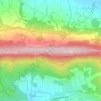
Name: Lägern topographic map, elevation, terrain.
Location: Lägern, Boppelsen, Bezirk Dielsdorf, Zürich, 8113, Schweiz (47.48177 8.39380 47.48187 8.39390)
Average elevation: 2,028 ft
Minimum elevation: 1,522 ft
Maximum elevation: 2,736 ft
Thank you for supporting this site ❤️
Make a donation
Make a donation
Gear up for your next adventure:
As an Amazon Associate, this site earns from qualifying purchases at no extra cost to you.