Geolocate

Huascar topographic map

Click on the map to display elevation.

About this map

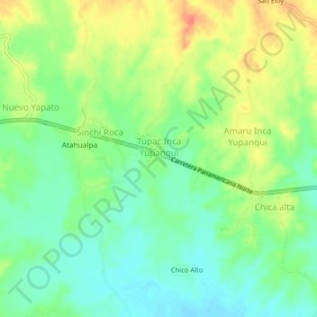
Name: Huascar topographic map, elevation, terrain.

Location: Huascar, Tambo Grande, Piura, Perú (-4.90644 -80.44684 -4.86644 -80.40684)

Average elevation: 276 ft

Minimum elevation: 207 ft

Maximum elevation: 371 ft

Other topographic maps

Click on a map to view its topography, its elevation and its terrain.

Rio Piura

Perú > Piura > Tambo Grande > Tambogrande

Average elevation: 315 ft

Gear up for your next adventure:

👟Trail Running Shoes - Lightweight shoes for trail runners
⛑️Personal Locator Beacon - Safety beacon for emergencies
🔦LED Headlamp - Bright and durable LED headlamp for night navigation
🧭Pro Hiking Compasses - High-accuracy liquid-filled compasses for topographic orientation
🔥Fast-Boil Camping Stoves - Efficient cooking systems for quick trail meals

As an Amazon Associate, this site earns from qualifying purchases at no extra cost to you.