
Make a donation
Gear up for your next adventure:
As an Amazon Associate, this site earns from qualifying purchases at no extra cost to you.
Drabenderhöhe topographic map
Click on the map to display elevation.
Make a donation
Gear up for your next adventure:
As an Amazon Associate, this site earns from qualifying purchases at no extra cost to you.
Drabenderhöhe
Lage von Drabenderhöhe in Wiehl
Make a donation
Gear up for your next adventure:
As an Amazon Associate, this site earns from qualifying purchases at no extra cost to you.
About this map
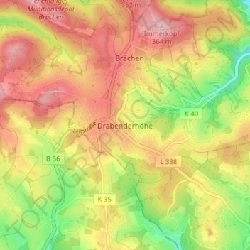
Name: Drabenderhöhe topographic map, elevation, terrain.
Average elevation: 942 ft
Minimum elevation: 633 ft
Maximum elevation: 1,188 ft
Make a donation
Gear up for your next adventure:
As an Amazon Associate, this site earns from qualifying purchases at no extra cost to you.
Other topographic maps
Click on a map to view its topography, its elevation and its terrain.
51674
Deutschland > Nordrhein-Westfalen > Oberbergischer Kreis > Wiehl > Altklef > Alperbrück
Average elevation: 781 ft
Weiershagen
Deutschland > Nordrhein-Westfalen > Oberbergischer Kreis > Wiehl
Durch Weiershagen fließt die Wiehl, hier verläuft auch die Bundesautobahn 4 in rund 70 Metern Höhe über die Wiehltalbrücke. Die Wiehltalbahn (Touristikverkehr) hat hier einen Haltepunkt reaktiviert.
Average elevation: 840 ft
Immen
Deutschland > Nordrhein-Westfalen > Oberbergischer Kreis > Wiehl > Drabenderhöhe
Der Ort bei Drabenderhöhe liegt in Luftlinie rund 6 Kilometer westlich des Stadtzentrums von Wiehl. Immen liegt südlich der Bundesautobahn 4.
Average elevation: 955 ft
Weiershagen
Deutschland > Nordrhein-Westfalen > Oberbergischer Kreis > Wiehl
Durch Weiershagen fließt die Wiehl, hier verläuft auch die Bundesautobahn 4 in rund 70 Metern Höhe über die Wiehltalbrücke. Die Wiehltalbahn (Touristikverkehr) hat hier einen Haltepunkt reaktiviert.
Average elevation: 840 ft
Make a donation
Gear up for your next adventure:
As an Amazon Associate, this site earns from qualifying purchases at no extra cost to you.