Geolocate

Arizona topographic map

Click on the map to display elevation.

About this map

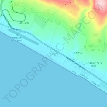
Name: Arizona topographic map, elevation, terrain.

Location: Arizona, Mollendo, Islay, Arequipa, 04416, Perú (-17.07040 -71.99279 -17.03040 -71.95279)

Average elevation: 141 ft

Minimum elevation: -3 ft

Maximum elevation: 869 ft

Other topographic maps

Click on a map to view its topography, its elevation and its terrain.

Laguna San Camilo

Perú > Arequipa > Mollendo

Average elevation: 3,763 ft

Lomas de Yuta

Perú > Arequipa > Mollendo

Average elevation: 1,677 ft

Gear up for your next adventure:

🧭GPS Watch Accessories - Bands and chargers for GPS watches
🧦Hiking Socks - Comfortable socks to prevent blisters on long hikes
🦶Hiking Gaiters - Keep debris and water out of your boots
🛏️Cold Weather Sleeping Bag - Warm sleeping bag for cold conditions
📶Satellite Messenger - Communication device off‑grid

As an Amazon Associate, this site earns from qualifying purchases at no extra cost to you.