Geolocate

Bernstein topographic map

Click on the map to display elevation.

About this map

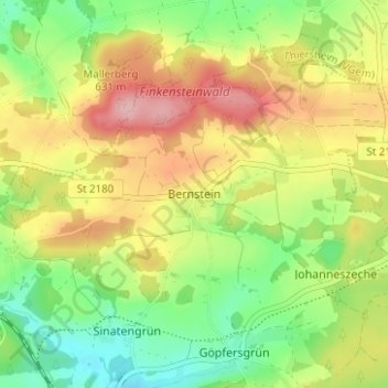
Name: Bernstein topographic map, elevation, terrain.

Location: Bernstein, Wunsiedel, Landkreis Wunsiedel im Fichtelgebirge, Bayern, 95186, Deutschland (50.05301 12.03515 50.09301 12.07515)

Average elevation: 1,975 ft

Minimum elevation: 1,755 ft

Maximum elevation: 2,234 ft

Other topographic maps

Click on a map to view its topography, its elevation and its terrain.

Gear up for your next adventure:

🩳Quick‑Dry Hiking Shorts - Comfortable and quick‑dry shorts for summer hiking
🪑Portable Camp Table - Compact table for campsite meals
📡GPS Antenna Upgrade - Enhance GPS reception in remote terrain
🪶Thermal Camp Blanket - Extra warmth for cold nights
📖Nature Tracking Books - Learn to track wildlife and terrain

As an Amazon Associate, this site earns from qualifying purchases at no extra cost to you.