Geolocate

Dela Paz topographic map

Click on the map to display elevation.

About this map

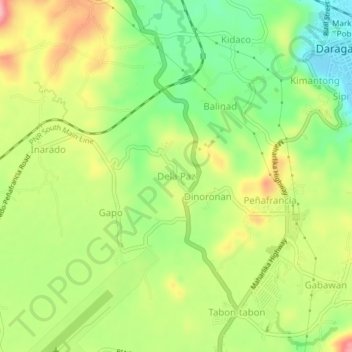
Name: Dela Paz topographic map, elevation, terrain.

Location: Dela Paz, Daraga, Albay, Bicol Region, 4501, Philippines (13.11341 123.67360 13.15341 123.71360)

Average elevation: 292 ft

Minimum elevation: 75 ft

Maximum elevation: 551 ft

Gear up for your next adventure:

🛡️Insect Repellent - Protection against bugs during outdoor activities
📶Satellite Messenger - Communication device off‑grid
🔦Powerful Headlamps - Ultra-bright hands-free lighting for night navigation
🌡️Portable Weather Meter - Track weather conditions on the trail
🎒Outdoor Daypacks - Lightweight backpacks designed for carrying maps and essential gear

As an Amazon Associate, this site earns from qualifying purchases at no extra cost to you.