
Ratekau topographic map
Click on the map to display elevation.
About this map
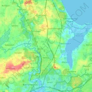
Name: Ratekau topographic map, elevation, terrain.
Location: Ratekau, Ostholstein, Schleswig-Holstein, Germany (53.91494 10.66061 54.01812 10.85061)
Average elevation: 66 ft
Minimum elevation: -13 ft
Maximum elevation: 240 ft
Other topographic maps
Click on a map to view its topography, its elevation and its terrain.
Pelzerhaken
Germany > Schleswig-Holstein > Ostholstein > Neustadt in Holstein
Average elevation: 26 ft