
Arzano topographic map
Click on the map to display elevation.
About this map
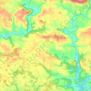
Name: Arzano topographic map, elevation, terrain.
Average elevation: 203 ft
Minimum elevation: 30 ft
Maximum elevation: 397 ft
Other topographic maps
Click on a map to view its topography, its elevation and its terrain.
Lotissement Le Clos de Kersioual
France > Brittany > Finistère > Port-la-Forêt
Average elevation: 82 ft
Port de Heign Has
France > Brittany > Finistère > Cléden-Cap-Sizun > Penharn
Average elevation: 102 ft
Manoir de Cœcilian (Saint-Pol-Roux)
France > Brittany > Finistère > Camaret-sur-Mer
Average elevation: 56 ft