Geolocate

Veraval topographic map

Click on the map to display elevation.

Veraval

Veraval is located at 20°54′N 70°22′E / 20.9°N 70.37°E / 20.9; 70.37. It has an average elevation of 0 metres (0 feet).

Wikipedia (CC-BY-SA 3.0)

About this map

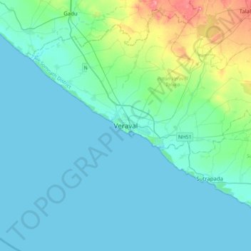
Name: Veraval topographic map, elevation, terrain.

Location: Veraval, Patan Veraval Taluka, Gir Somnath District, Gujarat, 362200, India (20.75011 70.20528 21.07011 70.52528)

Average elevation: 59 ft

Minimum elevation: 0 ft

Maximum elevation: 410 ft

Gear up for your next adventure:

🛶Inflatable Kayak - Portable kayak for rivers, lakes, and expeditions
🪄Magnetic Compass - Accurate compass for navigation
🦶Carbon Trekking Poles - Reduce knee impact on steep descents with ultra-light poles
🧣Merino Neck Gaiters - Multi-functional headwear for wind and sun protection
🗃️Trail First Aid Kit - Essential kit for outdoor injuries and emergencies

As an Amazon Associate, this site earns from qualifying purchases at no extra cost to you.