
Oakwood Villa topographic map
Interactive map
Click on the map to display elevation.
About this map
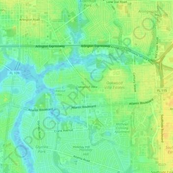
Name: Oakwood Villa topographic map, elevation, terrain.
Average elevation: 36 ft
Minimum elevation: -10 ft
Maximum elevation: 75 ft
Other topographic maps
Click on a map to view its topography, its elevation and its terrain.
Jacksonville
United States > Florida > Duval County > Jacksonville
Jacksonville, Duval County, Florida, 32202, United States
Average elevation: 30 ft
New Berlin
United States > Florida > Duval County > Jacksonville
New Berlin, Jacksonville, Duval County, Florida, 32277, United States
Average elevation: 7 ft
Eagle Bend Island Park
United States > Florida > Duval County > Jacksonville
Eagle Bend Island Park, Jacksonville, Duval County, Florida, United States
Average elevation: 10 ft
Plummer
United States > Florida > Duval County > Jacksonville
Plummer, Jacksonville, Duval County, Florida, 32219, United States
Average elevation: 20 ft
Ribault Monument
United States > Florida > Duval County > Jacksonville
Ribault Monument, Jacksonville, Duval County, Florida, 32225, United States
Average elevation: 16 ft
Marion Island
United States > Florida > Duval County > Jacksonville
Marion Island, Jacksonville, Duval County, Florida, United States
Average elevation: 10 ft
Jacksonville Heights
United States > Florida > Duval County > Jacksonville
Jacksonville Heights, Jacksonville, Duval County, Florida, 32222, United States
Average elevation: 79 ft
Grand Crossing
United States > Florida > Duval County > Jacksonville
Grand Crossing, Jacksonville, Duval County, Florida, 32254, United States
Average elevation: 26 ft
Hogan
United States > Florida > Duval County > Jacksonville
Hogan, Jacksonville, Duval County, Florida, 32216, United States
Average elevation: 30 ft
Beauclerc
United States > Florida > Duval County > Jacksonville
Beauclerc, Jacksonville, Duval County, Florida, 32257, United States
Average elevation: 16 ft
Oak Hill
United States > Florida > Duval County > Jacksonville
Oak Hill, Jacksonville, Duval County, Florida, 32210, United States
Average elevation: 43 ft
Murray Hill
United States > Florida > Duval County > Jacksonville
Murray Hill, Jacksonville, Duval County, Florida, 33205, United States
Average elevation: 30 ft
Black Hammock
United States > Florida > Duval County > Jacksonville
Black Hammock, Jacksonville, Duval County, Florida, United States
Average elevation: 7 ft
Brooklyn
United States > Florida > Duval County > Jacksonville
Brooklyn, Jacksonville, Duval County, Florida, 32204, United States
Average elevation: 20 ft
Holiday Hill
United States > Florida > Duval County > Jacksonville
Holiday Hill, Jacksonville, Duval County, Florida, 32260, United States
Average elevation: 33 ft
Beechwood
United States > Florida > Duval County > Jacksonville
Beechwood, Jacksonville, Duval County, Florida, 32246, United States
Average elevation: 43 ft
Southside Estates
United States > Florida > Duval County > Jacksonville
Southside Estates, Jacksonville, Duval County, Florida, 32260, United States
Average elevation: 43 ft
Biltmore
United States > Florida > Duval County > Jacksonville
Biltmore, Jacksonville, Duval County, Florida, 32254, United States
Average elevation: 26 ft
Chaseville
United States > Florida > Duval County > Jacksonville
Chaseville, Jacksonville, Duval County, Florida, 32277, United States
Average elevation: 13 ft
Enchanted Park
United States > Florida > Duval County > Jacksonville
Enchanted Park, Jacksonville, Duval County, Florida, 32244, United States
Average elevation: 66 ft
Beverly Hills
United States > Florida > Duval County > Jacksonville
Beverly Hills, Jacksonville, Duval County, Florida, 32209, United States
Average elevation: 23 ft
Wesconnett
United States > Florida > Duval County > Jacksonville
Wesconnett, Jacksonville, Duval County, Florida, 32210, United States
Average elevation: 23 ft
San Jose
United States > Florida > Duval County > Jacksonville
San Jose, Jacksonville, Duval County, Florida, 32217, United States
Average elevation: 23 ft
Cambon
United States > Florida > Duval County > Jacksonville
Cambon, Jacksonville, Duval County, Florida, 32220, United States
Average elevation: 59 ft
South Metro
United States > Florida > Duval County > Jacksonville
South Metro, Jacksonville, Duval County, Florida, 32207, United States
Average elevation: 30 ft
San Mateo
United States > Florida > Duval County > Jacksonville
San Mateo, Jacksonville, Duval County, Florida, 32218, United States
Average elevation: 23 ft
Fort George Island
United States > Florida > Duval County > Jacksonville
Fort George Island, Jacksonville, Duval County, Florida, 32228, United States
Average elevation: 10 ft
Lakewood
United States > Florida > Duval County > Jacksonville > Lakewood
Lakewood, Jacksonville, Duval County, Florida, 32217, United States
Average elevation: 23 ft
Lake Shore
United States > Florida > Duval County > Jacksonville > Lake Shore
Lake Shore, Jacksonville, Duval County, Florida, 32210, United States
Average elevation: 23 ft
Pineland Gardens
United States > Florida > Duval County > Jacksonville > Pineland Gardens
Pineland Gardens, Jacksonville, Duval County, Florida, 32216, United States
Average elevation: 30 ft
Marietta
United States > Florida > Duval County > Jacksonville
Marietta, Jacksonville, Duval County, Florida, 32099, United States
Average elevation: 56 ft
Ortega
United States > Florida > Duval County > Jacksonville > Ortega
Ortega, Jacksonville, Duval County, Florida, 32210, United States
Average elevation: 13 ft
Hyde Park
United States > Florida > Duval County > Jacksonville
Hyde Park, Jacksonville, Duval County, Florida, 32210, United States
Average elevation: 36 ft
Venetia
United States > Florida > Duval County > Jacksonville
Venetia, Jacksonville, Duval County, Florida, 32212, United States
Average elevation: 10 ft