
Make a donation
Gear up for your next adventure:
As an Amazon Associate, this site earns from qualifying purchases at no extra cost to you.
Schweinfurt topographic map
Click on the map to display elevation.
Make a donation
Gear up for your next adventure:
As an Amazon Associate, this site earns from qualifying purchases at no extra cost to you.
Schweinfurt
Typisches Kennzeichen ist der relativ geringe Niederschlag, mit knapp über 600 mm pro Jahr, durch die Lage der Stadt östlich des Landrückens Rhön–Spessart, auf der Leeseite. Die Winter sind mitunter sehr kalt, aber durch die für bayerische Verhältnisse niedrige Seehöhe die Übergangszeiten mild und die Sommer warm bis heiß. Während in den höher gelegenen Regionen Süddeutschlands der Frühling spät einzieht und in Folge der Klimaerwärmung heute relativ schnell in den Sommer übergeht, zieht das Frühjahr im Schweinfurter Becken bald ein und ist sehr ausgeprägt. Das führt zur frühen Obstblüte, vielfältiger Flora und guten klimatischen Bedingungen für Spargel- und Weinbauanbau (siehe: Weinbau).
Make a donation
Gear up for your next adventure:
As an Amazon Associate, this site earns from qualifying purchases at no extra cost to you.
About this map
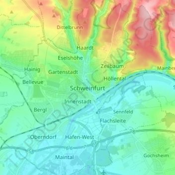
Name: Schweinfurt topographic map, elevation, terrain.
Location: Schweinfurt, Bayern, 97421, Deutschland (50.00999 10.19330 50.08999 10.27330)
Average elevation: 820 ft
Minimum elevation: 666 ft
Maximum elevation: 1,224 ft
Make a donation
Gear up for your next adventure:
As an Amazon Associate, this site earns from qualifying purchases at no extra cost to you.