
Thank you for supporting this site ❤️
Make a donation
Make a donation
Gear up for your next adventure:
As an Amazon Associate, this site earns from qualifying purchases at no extra cost to you.
Pimpilito topographic map
Click on the map to display elevation.
Thank you for supporting this site ❤️
Make a donation
Make a donation
Gear up for your next adventure:
As an Amazon Associate, this site earns from qualifying purchases at no extra cost to you.
About this map
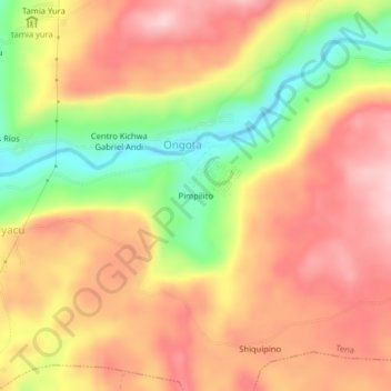
Name: Pimpilito topographic map, elevation, terrain.
Location: Pimpilito, Ongota, Tena, Napo, 101101, Ecuador (-1.01075 -77.80340 -0.97075 -77.76340)
Average elevation: 1,978 ft
Minimum elevation: 1,572 ft
Maximum elevation: 2,264 ft
Thank you for supporting this site ❤️
Make a donation
Make a donation
Gear up for your next adventure:
As an Amazon Associate, this site earns from qualifying purchases at no extra cost to you.