Geolocate

Noorvik topographic map

Click on the map to display elevation.

About this map

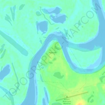
Name: Noorvik topographic map, elevation, terrain.

Location: Noorvik, Northwest Arctic, Alaska, 99763, United States (66.81423 -161.06106 66.85423 -161.02106)

Average elevation: 13 ft

Minimum elevation: -33 ft

Maximum elevation: 72 ft

Northwest Arctic trails, hiking, mountain biking, running and outdoor activities

Gear up for your next adventure:

🎒Trail Energy Bars - High‑calorie bars for hiking energy
💧Water Purification System - Clean water on the trail with reliable purifiers
🧢Sun Protection Hats - Wide-brimmed and UPF-rated hats for high-altitude sun safety
🔌Solar Panel Charger - Charge gear sustainably outdoors
🪑Portable Camp Table - Compact table for campsite meals

As an Amazon Associate, this site earns from qualifying purchases at no extra cost to you.