
Make a donation
Gear up for your next adventure:
As an Amazon Associate, this site earns from qualifying purchases at no extra cost to you.
Marbach-Stausee topographic map
Click on the map to display elevation.
Make a donation
Gear up for your next adventure:
As an Amazon Associate, this site earns from qualifying purchases at no extra cost to you.
Marbach-Stausee
Der Marbach-Stausee, der sich nur etwas südöstlich der Gemeinde Mossautal und nur wenig nordwestlich von Beerfelden befindet, ist mit etwa 22 ha Fläche bei Dauerstau und 49 ha bei Vollstau das flächenmäßig größte Stillgewässer des Odenwaldes. Sein Speicherraum umfasst 0,709 Mio. m³ bei Dauerstau und 3,11 Mio. m³ bei Vollstau, sein Einzugsgebiet rund 56 km² Fläche. Das Stauziel des Sees befindet sich bei 265,2 m ü. NHN. Die Höhe des Vollstaus beträgt 270,80 m.
Make a donation
Gear up for your next adventure:
As an Amazon Associate, this site earns from qualifying purchases at no extra cost to you.
About this map
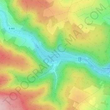
Name: Marbach-Stausee topographic map, elevation, terrain.
Average elevation: 1,184 ft
Minimum elevation: 840 ft
Maximum elevation: 1,585 ft
Make a donation
Gear up for your next adventure:
As an Amazon Associate, this site earns from qualifying purchases at no extra cost to you.