Saswad topographic map
Interactive map
Click on the map to display elevation.
About this map
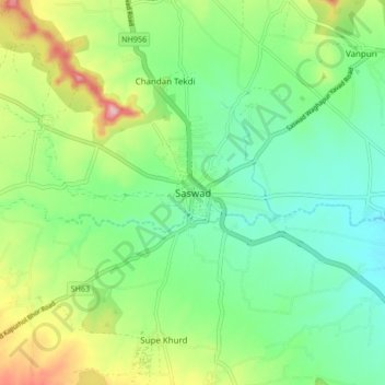
Name: Saswad topographic map, elevation, terrain.
Location: Saswad, Purandhar, Pune, Maharashtra, 412300, India (18.30443 73.98952 18.38443 74.06952)
Average elevation: 2,582 ft
Minimum elevation: 2,398 ft
Maximum elevation: 2,953 ft
Other topographic maps
Click on a map to view its topography, its elevation and its terrain.
Malhargad Fort
India > Maharashtra > Purandhar
Malhargad Fort, Malhargad Walking Path, Purandhar, Pune District, Maharashtra, India
Average elevation: 2,697 ft
Garade
India > Maharashtra > Purandhar
Garade, Purandhar, Pune, Maharashtra, 412205, India
Average elevation: 2,897 ft
Narayanpur
India > Maharashtra > Purandhar
Narayanpur, Purandhar, Maharashtra, 412302, India
Average elevation: 3,031 ft
Jejuri
India > Maharashtra > Purandhar
Jejuri, Purandhar, Pune, Maharashtra, 412303, India
Average elevation: 2,388 ft
Kalewadi
India > Maharashtra > Purandhar
Kalewadi, Purandhar, Pune, Maharashtra, India
Average elevation: 2,753 ft
Ketkawale
India > Maharashtra > Purandhar
Ketkawale, Purandhar, Pune, Maharashtra, 412302, India
Average elevation: 2,474 ft