
Make a donation
Gear up for your next adventure:
As an Amazon Associate, this site earns from qualifying purchases at no extra cost to you.
Rio Nido topographic map
Click on the map to display elevation.
Make a donation
Gear up for your next adventure:
As an Amazon Associate, this site earns from qualifying purchases at no extra cost to you.
About this map
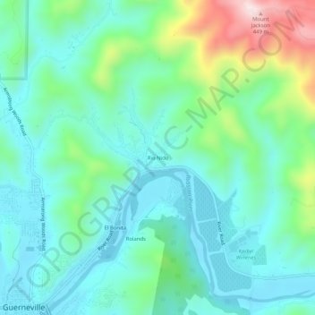
Name: Rio Nido topographic map, elevation, terrain.
Average elevation: 381 ft
Minimum elevation: 10 ft
Maximum elevation: 1,575 ft
Sonoma County trails, hiking, mountain biking, running and outdoor activities
Make a donation
Gear up for your next adventure:
As an Amazon Associate, this site earns from qualifying purchases at no extra cost to you.
Other topographic maps
Click on a map to view its topography, its elevation and its terrain.
Russian River
United States > California > Sonoma County > Guerneville > El Bonita
The geographer R. S. Holway wrote of the Russian River in his 1917 paper "The Russian River: A Characteristic Stream of the California Coast Ranges". Originally, the Russian River was one of several rivers draining westward from the Mayacamas Mountains through the Mendocino Plateau to the sea, a region lifted…
Average elevation: 591 ft