
Make a donation
Gear up for your next adventure:
As an Amazon Associate, this site earns from qualifying purchases at no extra cost to you.
Juniata Township topographic map
Click on the map to display elevation.
Make a donation
Gear up for your next adventure:
As an Amazon Associate, this site earns from qualifying purchases at no extra cost to you.
About this map
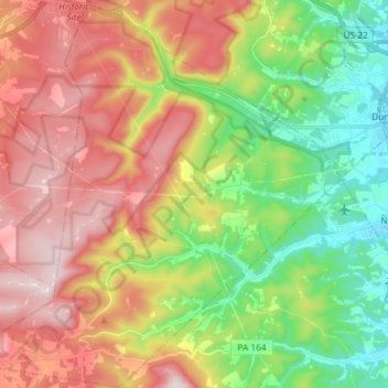
Name: Juniata Township topographic map, elevation, terrain.
Location: Juniata Township, Blair County, Pennsylvania, United States (40.34577 -78.60185 40.45665 -78.45568)
Average elevation: 1,870 ft
Minimum elevation: 1,037 ft
Maximum elevation: 2,844 ft
Blair County trails, hiking, mountain biking, running and outdoor activities
Make a donation
Gear up for your next adventure:
As an Amazon Associate, this site earns from qualifying purchases at no extra cost to you.
Other topographic maps
Click on a map to view its topography, its elevation and its terrain.
Yellow Spring
United States > Pennsylvania > Blair County > Catharine Township
Average elevation: 1,175 ft
Beverly Hills
United States > Pennsylvania > Blair County > Logan Township
Average elevation: 1,424 ft
Frankstown
United States > Pennsylvania > Blair County > Frankstown Township
Average elevation: 1,053 ft
Make a donation
Gear up for your next adventure:
As an Amazon Associate, this site earns from qualifying purchases at no extra cost to you.
Charlottsville
United States > Pennsylvania > Blair County > Antis Township
Average elevation: 1,148 ft