Geolocate

Riverside topographic map

Click on the map to display elevation.

About this map

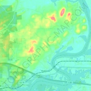
Name: Riverside topographic map, elevation, terrain.

Location: Riverside, St. Clair County, Alabama, 35135, United States (33.58693 -86.24214 33.65764 -86.16462)

Average elevation: 522 ft

Minimum elevation: 433 ft

Maximum elevation: 791 ft

St. Clair County trails, hiking, mountain biking, running and outdoor activities

Other topographic maps

Click on a map to view its topography, its elevation and its terrain.

Cook Springs

United States > Alabama > St. Clair County

Average elevation: 728 ft

Ragland

United States > Alabama > St. Clair County

Average elevation: 607 ft

Parsons

United States > Alabama > St. Clair County > Moody > Parsons

Average elevation: 702 ft

Cropwell

United States > Alabama > St. Clair County > Pell City

Average elevation: 509 ft

Gear up for your next adventure:

🗃️Trail First Aid Kit - Essential kit for outdoor injuries and emergencies
🌐World Map Poster - Decorative world maps with topographic info
🪶LED Camping Lantern - Bright lantern for camp lighting
📶Vehicle Signal Boosters - Improve reception in rural areas while driving to trailheads
📌Outdoor GPS Map App - Apps and devices for digital topographic navigation

As an Amazon Associate, this site earns from qualifying purchases at no extra cost to you.