
Make a donation
Gear up for your next adventure:
As an Amazon Associate, this site earns from qualifying purchases at no extra cost to you.
Bilbao topographic map
Click on the map to display elevation.
Make a donation
Gear up for your next adventure:
As an Amazon Associate, this site earns from qualifying purchases at no extra cost to you.
Bilbao
Bilbao is located in the north-central part of Spain, some 16 kilometres (10 mi) south of the Bay of Biscay, where the economic social development is located, where the estuary of Bilbao is formed. Its main urban core is surrounded by two small mountain ranges with an average elevation of 400 metres (1,300 ft). Its climate is shaped by the Bay of Biscay low-pressure systems and mild air, moderating summer temperatures by Iberian standards, with low sunshine and high rainfall. The annual temperature range is low for its latitude.
Make a donation
Gear up for your next adventure:
As an Amazon Associate, this site earns from qualifying purchases at no extra cost to you.
About this map
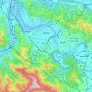
Name: Bilbao topographic map, elevation, terrain.
Average elevation: 512 ft
Minimum elevation: -7 ft
Maximum elevation: 2,211 ft
Make a donation
Gear up for your next adventure:
As an Amazon Associate, this site earns from qualifying purchases at no extra cost to you.
Other topographic maps
Click on a map to view its topography, its elevation and its terrain.
Gebara
Spain > Autonomous Community of the Basque Country > Arabako lautada/Llanada Alavesa
Average elevation: 1,883 ft
Larraitz
Spain > Autonomous Community of the Basque Country > Abaltzisketa
Average elevation: 1,565 ft
Make a donation
Gear up for your next adventure:
As an Amazon Associate, this site earns from qualifying purchases at no extra cost to you.
Gorbeia
Spain > Autonomous Community of the Basque Country > Gorbeialdea > Zeanuri
Average elevation: 3,901 ft
Marabi
Spain > Autonomous Community of the Basque Country > Amorebieta-Etxano
Average elevation: 528 ft
Make a donation
Gear up for your next adventure:
As an Amazon Associate, this site earns from qualifying purchases at no extra cost to you.
Karakate
Spain > Autonomous Community of the Basque Country > Debabarrena > Soraluze
Average elevation: 1,201 ft
Santa Barbara
Spain > Autonomous Community of the Basque Country > Hernani > Sorgintxulo
Average elevation: 223 ft
Soil
Spain > Autonomous Community of the Basque Country > Arabako Mendialdea
Average elevation: 2,946 ft
Bujal
Spain > Autonomous Community of the Basque Country > Añanako kuadrilla > Berantevilla
Average elevation: 1,755 ft
Make a donation
Gear up for your next adventure:
As an Amazon Associate, this site earns from qualifying purchases at no extra cost to you.
Araneta
Spain > Autonomous Community of the Basque Country > Gasteizko kuadrilla/Cuadrilla de Vitoria > Vitoria-Gasteiz > Bolívar
Average elevation: 2,051 ft
Soil
Spain > Autonomous Community of the Basque Country > Montaña Alavesa/Arabako Mendialdea
Average elevation: 2,946 ft
Makola
Spain > Autonomous Community of the Basque Country > Urola-Kosta > Azkoitia
Average elevation: 1,690 ft
Fuente Oneri
Spain > Autonomous Community of the Basque Country > Arabako lautada/Llanada Alavesa > Agurain/Salvatierra
Average elevation: 2,234 ft
Make a donation
Gear up for your next adventure:
As an Amazon Associate, this site earns from qualifying purchases at no extra cost to you.
Iruka
Spain > Autonomous Community of the Basque Country > Debabarrena > Eibar
Average elevation: 1,394 ft
Torrea
Spain > Autonomous Community of the Basque Country > Debabarrena > Eibar
Average elevation: 1,306 ft
Flysch
Spain > Autonomous Community of the Basque Country > Urola-Kosta > Zumaia
Average elevation: 89 ft
Make a donation
Gear up for your next adventure:
As an Amazon Associate, this site earns from qualifying purchases at no extra cost to you.
Barinatxe - La Salvaje
Spain > Autonomous Community of the Basque Country > Sopela
Average elevation: 85 ft
Lore-Toki
Spain > Autonomous Community of the Basque Country > Arabako Errioxa/Rioja Alavesa > Labastida/Bastida
Average elevation: 1,637 ft
Trevilla
Spain > Autonomous Community of the Basque Country > Karrantza Harana/Valle de Carranza > Concha
Average elevation: 1,093 ft
Make a donation
Gear up for your next adventure:
As an Amazon Associate, this site earns from qualifying purchases at no extra cost to you.
Make a donation
Gear up for your next adventure:
As an Amazon Associate, this site earns from qualifying purchases at no extra cost to you.
Floreaga
Spain > Autonomous Community of the Basque Country > Urola-Kosta > Azkoitia
Average elevation: 873 ft
Hondarribiko hondartza
Spain > Autonomous Community of the Basque Country > Gipuzkoako Bidasoa > Hondarribia
Average elevation: 102 ft
Monterredondo
Spain > Autonomous Community of the Basque Country > Añanako kuadrilla/Cuadrilla de Añana
Average elevation: 2,871 ft
Make a donation
Gear up for your next adventure:
As an Amazon Associate, this site earns from qualifying purchases at no extra cost to you.
Oñati
Spain > Autonomous Community of the Basque Country > Debagoiena > Oñati
Average elevation: 1,601 ft
Plaza de Larrazábal
Spain > Autonomous Community of the Basque Country > Bilbao
Average elevation: 331 ft
Gautegiz Arteaga
Spain > Autonomous Community of the Basque Country > Gautegiz Arteaga > Gautegiz Arteaga
Average elevation: 341 ft
Make a donation
Gear up for your next adventure:
As an Amazon Associate, this site earns from qualifying purchases at no extra cost to you.
Zaldibar
Spain > Autonomous Community of the Basque Country > Zaldibar > Zaldibar
Average elevation: 1,001 ft
Soil
Spain > Autonomous Community of the Basque Country > Montaña Alavesa/Arabako Mendialdea
Average elevation: 2,946 ft