
Make a donation
Gear up for your next adventure:
As an Amazon Associate, this site earns from qualifying purchases at no extra cost to you.
Ladysmith topographic map
Click on the map to display elevation.
Make a donation
Gear up for your next adventure:
As an Amazon Associate, this site earns from qualifying purchases at no extra cost to you.
About this map
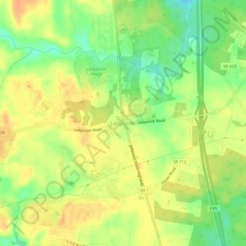
Name: Ladysmith topographic map, elevation, terrain.
Location: Ladysmith, Caroline County, Virginia, 22501, United States (37.99764 -77.53526 38.03764 -77.49526)
Average elevation: 230 ft
Minimum elevation: 157 ft
Maximum elevation: 279 ft
Caroline County trails, hiking, mountain biking, running and outdoor activities
Make a donation
Gear up for your next adventure:
As an Amazon Associate, this site earns from qualifying purchases at no extra cost to you.
Other topographic maps
Click on a map to view its topography, its elevation and its terrain.
Mattaponi Wildlife Management Area
United States > Virginia > Caroline County
Average elevation: 141 ft