Geolocate

Ezel topographic map

Click on the map to display elevation.

About this map

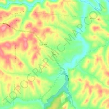
Name: Ezel topographic map, elevation, terrain.

Location: Ezel, Morgan County, Kentucky, 41425, United States (37.87120 -83.46435 37.91120 -83.42435)

Average elevation: 958 ft

Minimum elevation: 791 ft

Maximum elevation: 1,119 ft

Morgan County trails, hiking, mountain biking, running and outdoor activities

Other topographic maps

Click on a map to view its topography, its elevation and its terrain.

West Liberty

United States > Kentucky > Morgan County

Average elevation: 883 ft

West Liberty

United States > Kentucky > Morgan County

Average elevation: 883 ft

Gear up for your next adventure:

👓Polarized Sunglasses - Outdoor sunglasses for glare reduction
🧭Compass with Lanyard - Easy‑carry compass for navigation
🪶Fire Starter Kit - Reliable fire starter for survival and camping
🏔️Mountain Trail Maps - High‑detail maps for popular peaks
🔋Rechargeable Batteries - Power up your outdoor devices

As an Amazon Associate, this site earns from qualifying purchases at no extra cost to you.