Geolocate

Stillwater topographic map

Click on the map to display elevation.

About this map

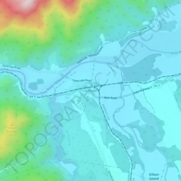
Name: Stillwater topographic map, elevation, terrain.

Location: Stillwater, Grey District, West Coast, New Zealand (-42.45720 171.33282 -42.41720 171.37282)

Average elevation: 315 ft

Minimum elevation: 33 ft

Maximum elevation: 1,860 ft

Other topographic maps

Click on a map to view its topography, its elevation and its terrain.

Lake Avernus

New Zealand > West Coast > Grey District

Average elevation: 4,380 ft

Gear up for your next adventure:

🌡️Handheld Weather Meters - Measure wind, temp, and pressure for safe mountain travel
💧Water Purification System - Clean water on the trail with reliable purifiers
🪶Trail Camera - Capture wildlife on your hikes
🍳Camping Cook Set - Complete cookware for outdoor meals
🖼️Topo Map Wall Art - Decorative topographic prints of famous peaks and regions

As an Amazon Associate, this site earns from qualifying purchases at no extra cost to you.